On July 23, 2005, at the Watermark Wingspread Conference, Dr. John Day of Louisiana State University gave a presentation featuring a computer simulation of a catastrophic hurricane event in NOLA, based on a levee protection level of category 4. He related how healthy wetlands could mitigate the effects of such storms.
On August 29, 2005, Hurricane Katrina (category 3 strength) hit the Louisiana coast. Due to substandard levee construction, 80% of New Orleans suffered severe flooding. To date, 1,836 people lost their lives in the storm - 1,577 in Louisiana alone. 705 are missing. The catastrophe was human-caused.
In November of 2005, filmmakers Marylou and Jerome Bongiorno visited New Orleans to witness and document the devastation and deteriorating wetlands.
"The first thing we learned was that the devastation of NOLA was due to two things...”
-
•Failure of category 4 designed levees to protect the city against a category 3 Hurricane.
-
•Draining NOLA swamps decades ago and building houses below sea level. Building below sea level requires constant and expensive maintenance to keep water out. This is an unsustainable practice anywhere. If any rebuilding is to occur, all homes must first be rebuilt on stilts, well above sea level.
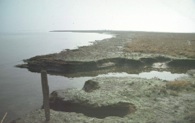
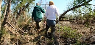
The filmmakers accompanied Dr. John Day into the eroding wetlands, the focus of his life's research. The second thing the filmmakers learned was that an enormous amount of natural capital has been lost in the destruction of the Louisiana wetlands. They are a victim of the following factors:
-
•Diking of the Mississippi River - causes low sedimentation which is starving the marsh.
-
•Erosive action of access canals. Since the 1930s, natural gas and oil companies have dug 10,000 miles of access canals through the wetlands:
-
•These canals usher saltwater from the gulf, deep into the wetlands. Too high a salinity concentration can overwhelm plants and animals not ready for the salt.
-
•When marsh die, the area loses its ability to dampen tidal and wave action - especially important during a hurricane. Army Core of Engineers says that each 2.7 miles of healthy marsh can decrease a storm surge by 1 foot.
-
•When gas and oil are extracted, the land sinks and the marshes drown.
-
•Erosive action of waterways like "Mr. Go." Mr. Go was a channel constructed by the United States Army Corps of Engineers to provide ships a shorter route between the Gulf of Mexico and New Orleans. During hurricane Katrina, MR-GO channelled the storm's surge into New Orleans, contributing significantly to the multiple levee failures. (Mr. Go was closed in 2007)
Dr. Day: “Over the twentieth century, almost 4000 square miles [of wetlands] eroded away. An enormous area. Some people compare it to the size of Connecticut. I mean, it's an enormous area of natural habitat that's been lost.”
The take-home on NOLA for the filmmakers is that the city and environs have been a victim of alterations made to favor industry.
In NOLA, the Bongiornos interviewed hurricane victims and photographed the flood-devastated parishes of New Orleans. Protecting New Orleans and NOLA are 2 in their series of short films documenting this experience. Protecting New Orleans premiered on the Emmy-winning national PBS series "Natural Heroes," and both films are screening internationally. The Bongiornos' NOLA video installations and photographs are exhibited in museums and galleries.
PROTECTING NEW ORLEANS, SAVING VENICE

Season Premiere for the national PBS, Emmy-winning NATURAL HEROES
Photos courtesy of NOAA

photo, courtesy of Dr. John Day
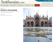
SAVING VENICE


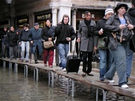
In November of 2006, the filmmakers visited Venice, Italy. Similar to New Orleans, the city of Venice and its marshes are under much stress. The filmmakers found that, like New Orleans, Venice’s flooding is human-caused.
The major issue with Venice is the increasing frequency of lagoon flooding. To combat this, maintenance for Venice has included:
-
•Sidewalks raised
-
•Canals dredged
-
•Sewage systems fixed to prevent back flow of water
The increased flooding is not a natural occurrence nor is it being caused by sea level rise due to anthropogenic global warming. The flooding is due to decades-long lagoon alterations that had favored industry. As a result of those alterations, too much salt water from the Adriatic flows into the lagoon.
Alterations have included:
From 1930 - 1970: fresh water was pumped out of the aquifer beneath Venice to feed the oil refining industries at Marghera (instead of retrofitting pipes to accept corrosive salty water from the lagoon). This pumping led to a 10 cm subsidence of Venice. This is like losing 70 years against natural sea level rise (sea level has been naturally rising since the end of the last ice age 18,000 years ago).
Large, deep shipping channels were dug to allow oil tankers and tourist ships to navigate through the lagoon. These channels usher in massive amounts of salt water that flood the city and marshes and gouge the bottom of the lagoon further dampening the lagoon’s natural hydraulic resistance. Also, too high a salinity concentration can overwhelm plants and animals not ready for the salt.
Fisheries and reclaimed farmland (bonifica) separate off areas of the lagoon from water absorption abilities.
Since there is less lagoon area to absorb the water, the marsh and city (especially the older, lower parts of the city, e.g.. San Marco), during the rainy season (October to February), are inundated with water.
Primary solutions to Venice’s flooding should focus on reversing the alterations such as:
-
•Closing the deep channels and docking ships in the Adriatic
-
•Closing fish farms and reclaiming the bonifica as marshland
-
•Marghera aquifer pumping ceased in 1970 but the subsidence is irreversible
Secondary solutions should adhere to a 1984 Special Law that mandated that any solutions be (a) gradual (b) experimental and (c) reversible. These solutions include:
-
•Overturned Boats:
-
A low cost, gradual, and reversible procedure such as using overturned sunken boats as barriers to increase the hydraulic resistance at the mouth of the lagoon, would slow the incoming water. With placement of a few boats at a time, in a gradual process, scientists can fine-tune boat location for maximum effectiveness.
-
•Sewage System:
-
Since Venice still dumps its sewage into the lagoon and therefore still largely depends on the tide to flush its sewage, slowing the tide through hydraulic resistance would then necessitate the creation of a sewage system.
-
•Rivers Opened to Sediment:
-
Centuries ago, rivers feeding the lagoon were diverted to prevent the silting-up of the lagoon. As a result, one of the reasons why the Venetian wetlands are unable to keep up with the extra incoming water today is the inadequate influx of sediment from the few surrounding rivers that still feed into the lagoon. In addition, due to the large, deep shipping channels, there is a large amount of sedimentation loss to the Adriatic. A solution would to be to close the deep shipping channels and open the closed rivers to the lagoon in a controlled fashion to reintroduce more river sediment. Further, any opening of rivers would necessitate cleaning the runoff of agricultural pollution.
Using gradual, experimental and reversible measures, flooding control could be brought back to tidal fluctuations of 100 years ago.
THE MOSE
In place of these solutions, what is currently being done is a very high cost, non-experimental, non-reversible system of submergible dams known as MOSE (MOdulo Sperimentale Elettromeccanico, Experimental Electromechanical Module). This system (designed in the early 70s) was created so industry and tourism can continue unabated.
Major issues with the MOSE include:
-
•Very expensive to build and maintain, therefore less money for vital city maintenance
-
•It is not gradual in design; the entire system of 79 gates must be in place for the design to work
-
•Placement into the mouth of the lagoon is irreversible
-
•Except for small scale design testing, the MOSE system is untested, and once in place, there is no room for modification
-
•Zinc, used to coat the gates to prevent corrosion and sea life encrustation, will contaminate the lagoon water and enter the food chain
-
•Early design has not taken into consideration possible accelerated sea level level rise due to anthropogenic global warming. If IPCC estimates of sea level rise due to anthropogenic global warming are accurate (i.e. a 59 cm rise in sea level by 2100), the MOSE will close daily during the high tide. Since the lagoon currently depends upon tidal fluctuations to clean it, daily closures would lead to a polluted lagoon.
Scientific surveys show that as a result of the increased water influx, Venice salt marshes and mud flats are down to a third of their extent. Approximately 20% of the Venice lagoon’s plants and 50% of bird species have been lost since 1930.
The filmmakers’ expanded short film Protecting New Orleans, Saving Venice presents the plight and proposed solutions to save both cities.


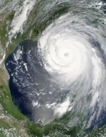
Satellite photo of hurricane Katrina, 2005
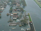
17th Street Canal Levee Breach,
NOLA 2005
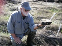
Dr. John Day
Venice, Italy - dying wetlands
PROTECTING NEW ORLEANS


Photos courtesy of USACE

Read Smithsonian Article with Marylou and Jerome Bongiorno
Read the Smithsonian Article &
See the Venice pix
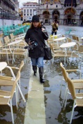
Filmmaker Marylou Tibaldo-Bongiorno
in Piazza San Marco, Italy
Dr. John Day and Marylou Tibaldo-Bongiorno
in the Louisiana wetlands
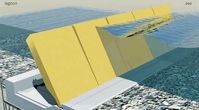
The Mose gates
Duck planks in a flooded Piazza San Marco